
28 Oct Mapping the Sea Through Law: Baselines and Maritime Spaces of the Colombian Archipelago


Cover design: CEMarin Communications Team
Island Geography and the Need to Measure the Sea
The Archipelago of San Andrés, Providencia and Santa Catalina has features that are uncommon within Colombia’s political geography. Its inhabited islands, cays, banks, and reefs are distributed across an extensive area of the western Caribbean and are connected by historical, economic, cultural, and ecological relationships that do not always coincide with the distribution of areas subject to State sovereignty or jurisdiction. This distinctive character becomes apparent when the archipelago is represented on a nautical chart: land features are relatively small and separated by broad expanses of sea, while coral formations affect how the physical edge of some islands is interpreted. The archipelago’s territorial dimension is undisputed under Colombia’s domestic legal order, but the maritime projection of its components requires the application of specific rules of the law of the sea. For Colombia, these rules apply primarily as customary international law, and the Constitution recognizes the relevant maritime spaces (Political Constitution of Colombia, 1991, arts. 101 and 310; Office of the President of the Republic of Colombia, 2013).
One of the fundamental instruments for this task is the baseline, from which the breadth of the territorial sea is measured and the outer limits of other maritime spaces are calculated. In general terms, the normal baseline follows the low-water line along the coast, whereas a straight baseline may connect appropriate points where the coast is deeply indented or where a fringe of islands lies in its immediate vicinity. Islands situated on atolls or bordered by reefs may, where the relevant conditions are met, use the low-water line on the seaward side of the reef as a special reference. These are distinct geographic solutions, and choosing among them is not discretionary: it depends on the physical circumstances and the applicable rules in each case (United Nations, 1982, arts. 5, 6, and 7).
It should be clarified from the outset that determining a baseline is not equivalent to unilaterally establishing a maritime boundary with another country. The first operation identifies the starting point for measuring maritime spaces; the second determines the allocation of rights when the projections of two States overlap. The regime of archipelagic baselines is also different: under the United Nations Convention on the Law of the Sea, it is reserved for States defined as archipelagic States, a category into which a continental State does not automatically fall simply because it has island territories. Colombia is not a party to that Convention, although, as the International Court of Justice has explained, several of its rules reflect customary international law applicable to the country’s maritime disputes (United Nations, 1982, arts. 46 and 47; International Court of Justice, 2022).
A Legal Mandate That Began in 1978
The regulatory history of Colombia’s baselines has a clear starting point. Law 10 of 1978 established the breadth of the territorial sea at twelve nautical miles, regulated the exclusive economic zone, and provided that the low-water line would be the ordinary reference for measuring the territorial sea, without excluding the exceptional use of straight baselines. Article 9 assigned the Government the task of designating those baselines both along the mainland and in the Archipelago of San Andrés and Providencia and the other island territories, and required their publication on official maritime charts. The law therefore established an obligation combining legal decisions, hydrographic surveys, and cartographic publication (Congress of Colombia, 1978).
In 1984, Decree 1436 developed the rules for certain sections of the mainland coast by identifying straight-baseline segments and their respective geographic endpoints. It did not, however, establish all the baselines for every formation in the insular Caribbean. This distinction is understandable given that the archipelago presents specific measurement challenges related to the distribution of its islands, the nature of its reefs, and the identification of suitable baseline points (Office of the President of the Republic of Colombia, 1984). The subsequent regulation therefore did not arise from an absence of general rules, but from the need to implement that mandate for a territory with a distinctive configuration.
The 1991 Constitution and Law 47 of 1993 provided an additional framework for recognizing the territorial and administrative unity of the Archipelago Department. This recognition is important for the exercise of public powers and the organization of State services, although it does not eliminate the distinctions that international law establishes between internal waters, the territorial sea, the contiguous zone, the exclusive economic zone, and the continental shelf. The political unity of a department and the legal continuity of its waters are separate matters. This conceptual distinction helps explain the scope of later administrative decisions and avoids attributing to cartography functions that belong to international delimitation (Political Constitution of Colombia, 1991; Congress of Colombia, 1993).
What Decree 1946 of 2013 Regulated
Decree 1946 of September 9, 2013, implemented legal provisions concerning the territorial sea, the contiguous zone, and certain aspects of the continental shelf of Colombia’s island territories in the western Caribbean. Article 1 identified the archipelago’s principal formations, including San Andrés, Providencia, Santa Catalina, Alburquerque, the East-Southeast Cays, Roncador, Serrana, Quitasueño, Serranilla, and Bajo Nuevo. Article 3 established criteria for determining their baseline points and lines, expressly referring to applicable international law and the particular features of atolls and reefs. It did not, however, include a comprehensive list of coordinates that would allow the entirety of those lines to be reconstructed independently. The specific designation of reference points therefore remained an action to be formalized and incorporated into official cartography (Office of the President of the Republic of Colombia, 2013, arts. 1 and 3).
The best-known feature of that decree was the so-called Integral Contiguous Zone. To understand it, it is necessary to recall that the contiguous zone may extend up to twenty-four nautical miles measured from the baselines and allows the coastal State to exercise specific powers to prevent and punish infringements relating mainly to customs, fiscal, immigration, and sanitary matters committed within its territory or territorial sea. Article 5 of Decree 1946 of 2013 recognized the contiguous zones associated with the island formations and directed that some of their outer limits be connected by geodesic lines, expressly aiming to facilitate orderly administration, avoid irregular outlines, and provide territorial cohesion to the island group. Its description included a geographic reference at 14°59′08″ north latitude and 79°56′00″ west longitude, related to a connection toward Serranilla (Office of the President of the Republic of Colombia, 2013, art. 5; United Nations, 1982, art. 33).
The Integral Contiguous Zone and baselines are therefore related but not equivalent elements. Baselines provide the reference from which distances are calculated, whereas the outer limit of the former is constrained by a maximum breadth and by the powers that international law recognizes for that maritime space. A continuous outline may make the zone easier to understand administratively, but it does not replace the distance calculation from the legally relevant baselines. This distinction explains many of the issues later considered by the International Court of Justice (International Court of Justice, 2022, paras. 164–186).
The 2014 Amendment and the Charts Issued by DIMAR
Decree 1119 of June 17, 2014, amended the earlier regulation. It clarified the distinction between sovereignty over island territories and the territorial sea, on the one hand, and jurisdiction and sovereign rights in other maritime spaces, on the other; reformulated certain control powers within the Integral Contiguous Zone; and added a general reference to international law. The change of greatest interest from a cartographic perspective appears in Article 4, which amended Article 6 of Decree 1946. The new wording provided that the baseline points and lines, as well as the Integral Contiguous Zone, were to be represented on official thematic maps prepared by the General Maritime Directorate (DIMAR), and that their determination was to be established by decree of the national Government. It also made publication of the charts conditional on the issuance of that legal act (Office of the President of the Republic of Colombia, 2014).
This provision was directly related to an earlier action by the maritime authority. Through Resolution 613 of December 9, 2013, DIMAR had issued eight thematic charts concerning the territorial sea of the island formations and different sectors of the archipelago. These included general chart 1200 and charts 1201, 1211, 1416, 1418, 1634, 1654, and 1655, corresponding to specific island groups and cays. There is therefore official evidence of cartographic production associated with the regime established in 2013. What should not be confused, however, is the issuance of charts with confirmation that all their coordinates were adopted and published through the procedure established after the 2014 amendment (General Maritime Directorate, 2013; Office of the President of the Republic of Colombia, 2014).
The distinction may appear administrative, but it has consequences for the legal traceability of geographic information. To establish the full status of a line, it is necessary to have both the legal act that establishes it and the charts that represent it, together with their technical specifications: geodetic datum, scale, accuracy, and, where applicable, vector files for the points and segments. A resolution confirming that charts were issued is a relevant antecedent; on its own, it does not make it possible to reproduce an entire perimeter without access to the original data. Likewise, failure to locate those files in a public search does not prove that they do not exist. This qualification should be maintained in any reconstruction of the island maritime spaces.
The Scope of the International Court of Justice Decisions
Three judgments of the International Court of Justice provide essential reference points for understanding the framework within which this regulation operates. In 2012, the Court decided sovereignty issues concerning disputed island formations and delimited the exclusive economic zone and continental shelf between Colombia and Nicaragua. Recognition of Colombia’s sovereignty over certain islands and cays did not mean that Colombia was granted all maritime spaces located between them. The decision made clear that title to a land formation and the extent of its maritime projection are related but legally distinct matters (International Court of Justice, 2012).
The judgment of April 21, 2022, directly addressed the regime of the Integral Contiguous Zone. The Court recognized Colombia’s right to establish contiguous zones around the archipelago and clarified that, under certain conditions, a Colombian contiguous zone may spatially overlap with Nicaragua’s exclusive economic zone because the two regimes confer different powers. Geographic coexistence does not in itself constitute a violation. Nevertheless, the Court concluded that some segments of the outline defined for the Integral Contiguous Zone exceeded the permitted twenty-four nautical miles and that certain powers, framed broadly in terms of security, national maritime interests, and environmental preservation, went beyond the proper scope of a contiguous zone. The Court recognized specific treatment for objects of an archaeological and historical nature and ordered Colombia to bring the relevant provisions into line insofar as they affected maritime spaces attributed to Nicaragua (International Court of Justice, 2022, paras. 145–194).
In the same judgment, the Court examined the straight baselines Nicaragua had established along its Caribbean coast and recalled the restrictive geographic conditions under which they may be used. This examination is relevant as a general interpretive reference, regardless of which State draws the line. The 2023 judgment, in turn, resolved a different dispute concerning Nicaragua’s claims to continental shelf beyond 200 nautical miles; it did not replace the 2012 delimitation or determine Colombia’s island baselines (International Court of Justice, 2022, paras. 234–260; International Court of Justice, 2023).
These judgments must also be read in light of Colombia’s position toward them. A few days after the 2012 ruling, the Government denounced the Pact of Bogotá, the treaty that formed the basis of the Court’s jurisdiction over Nicaragua’s applications. The denunciation took effect on November 27, 2013, and the applications that led to the 2022 and 2023 judgments had been filed before that date. In 2014, the Constitutional Court held that, under Article 101 of the Constitution, the country’s boundaries may be modified only through treaties approved by Congress, meaning that the 2012 delimitation is not incorporated into domestic law without that step. This position does not alter the binding nature of the judgments at the international level, but it explains the continuing tension between the two legal planes. The sources consulted also did not reveal any act issued after 2022 that amended Decree 1946 in the terms ordered by the Court (Constitutional Court of Colombia, 2014; International Court of Justice, 2022, paras. 193–194).
Taken together, these decisions make it possible to distinguish three matters that must be studied using different instruments: recognition of sovereignty over land formations; measurement and delimitation of maritime spaces; and the scope of State powers that may be exercised within them. This distinction is also important for the archipelago’s communities, particularly the Raizal population and its traditional navigation and fishing practices. In 2022, the Court examined claims concerning historical artisanal fishing rights, although it considered that the evidence submitted did not establish the rights asserted in waters of Nicaragua’s exclusive economic zone. This judicial outcome does not diminish the cultural and social importance of traditional fishing, but it requires a distinction between community recognition and the legal conditions for exercising those rights in spaces subject to different jurisdictions (International Court of Justice, 2022, paras. 201–233).
What Cartography Exists and What Information Still Needs to Be Cross-Checked
The documentary review makes it possible to answer a frequently asked question in the affirmative: cartographic representations related to the Integral Contiguous Zone do exist. In addition to the eight thematic charts issued by DIMAR, Colombia submitted during the proceedings before the International Court of Justice a map of the zone, reproduced in the 2022 judgment and taken from Figure 5.1 of its Counter-Memorial. This item is useful for observing the spatial configuration presented by the State in the proceedings and for understanding how the connections between different contiguous zones were represented. Its function must nevertheless be understood within the judicial record. The existence of that figure does not mean that the line was declared compliant with international law, nor does it replace the charts and adoption acts required under Colombia’s legal system (General Maritime Directorate, 2013; International Court of Justice, 2022).
To examine the line defended by Colombia during the proceedings before the Court, Figure 5.1 of its Counter-Memorial, reproduced in the 2022 judgment, should be consulted (International Court of Justice, 2022, p. 63). Later, in the section devoted to conservation, Figure 1 presents an analytical reconstruction of the Integral Contiguous Zone overlaid with the 2012 boundary and the archipelago’s protected areas, subject to the limitations imposed by the absence of official coordinates.
A complete cartographic reconstruction requires information that cannot be inferred from a schematic representation or an analytical reconstruction. The original coordinates, the physical nature of each point, the geodetic system used, and the criteria used to represent the segments are essential. Normal baselines, straight baselines, and the special rules applicable to reefs and atolls must also be distinguished. It is likewise important to separate charts depicting the territorial sea from those representing a contiguous zone or an international boundary that has already been delimited. During the documentary review conducted for this article, it was not possible to publicly verify a complete set of geospatial files that would allow all these operations to be performed. This observation identifies a limitation in the sources consulted; it does not establish that the information is absent from State archives.
Cartographic representation can therefore serve two complementary functions. On the one hand, it is the technical means of translating legal rules into verifiable distances, points, and areas; on the other, it provides information that facilitates cooperation among authorities, researchers, and users of the sea. In both cases, documenting the procedures matters as much as the final map. A boundary shown graphically is easier to understand when it is possible to determine which baseline was used to calculate it, which hydrographic sources were consulted, and which legal act supports its adoption.
Coral Reefs, Conservation, and Marine Governance
The archipelago’s environmental dimension introduces an additional consideration. Its reefs, banks, and atolls are not merely geographic features relevant to calculating maritime spaces; they form part of ecological systems that support fisheries, contribute to coastal protection, and host exceptional biological diversity. The designation of the Seaflower Biosphere Reserve in 2000 and the establishment of the Seaflower Marine Protected Area through Resolution 107 of 2005 demonstrate the growing importance of conservation instruments in the administration of the island territory. Among the aims of the protected area, CORALINA highlights habitat conservation, sustainable resource use, and the participation of local communities in management (CORALINA, 2023).
Baselines, marine protected areas, and environmental planning areas do not serve the same function. Baselines establish the geographic starting point for measurements provided for under the law of the sea; protected areas establish conservation objectives and rules within defined areas of authority. Therefore, the location of an ecosystem within a biosphere reserve or protected area does not, by itself, alter an international delimitation or automatically expand a State’s powers over another State’s exclusive economic zone. The 2022 judgment made this distinction particularly clear when examining the environmental powers Colombia had incorporated into its contiguous-zone regulations (International Court of Justice, 2022; CORALINA, 2023).
Figure 1 applies this distinction spatially by overlaying three sets of information, usually examined separately, on a single georeferenced base: the maritime boundary established by the International Court of Justice in 2012, including the twelve-nautical-mile enclaves around Quitasueño and Serrana; the boundaries of the Seaflower Biosphere Reserve, the Seaflower Marine Protected Area, and Old Providence McBean Lagoon National Natural Park, taken from official protected-area records; and a reconstruction of the Integral Contiguous Zone prepared according to the criteria in Article 5 of Decree 1946 of 2013. In the absence of official baseline coordinates, the zone’s outline was obtained by connecting, with geodesic lines, the twenty-four-nautical-mile bands around each formation, calculated from the territorial seas recognized by the Court or, in the cases of San Andrés, Providencia, and Roncador, from approximate outlines of their islands and reefs. The result is therefore analytical: it makes it possible to compare regimes, but it does not replace the cartography that Colombian authorities are responsible for adopting (International Court of Justice, 2012; Office of the President of the Republic of Colombia, 2013, art. 5; Flanders Marine Institute, 2023; National Natural Parks of Colombia, 2026).
Reading the layers together reveals two situations described in legal terms by the 2022 judgment. The first concerns breadth: nearly one-third of the reconstructed area of the Integral Contiguous Zone—approximately 24,300 of its 77,900 square kilometers—lies more than twenty-four nautical miles from any formation, particularly in the spaces covered by the continuous outline between the cays and in the corridor extending toward Serranilla. These sectors, rather than the existence of the zone itself, are what the Court considered contrary to customary international law (International Court of Justice, 2022, paras. 170–175). The second concerns jurisdiction: the Biosphere Reserve and the Marine Protected Area were designated before the 2012 delimitation and, according to the records consulted, retain the boundaries drawn at that time. As a result, approximately 48% of the protected area and 35% of the reserve now lie within the exclusive economic zone recognized as belonging to Nicaragua. In those sectors, the geographic overlap between the conservation instrument and the contiguous zone does not confer environmental powers on Colombia, as the Court clarified when examining Article 5 of the decree (International Court of Justice, 2022, paras. 176–180). In short, the map shows that conservation and jurisdiction share the same sea, but not the same rules. Seaflower’s ecological continuity is verifiable; what remains pending is translating it into cooperation mechanisms compatible with the jurisdictions established by the 2012 boundary (Institute of Marine and Coastal Research, 2026; CORALINA, 2023).
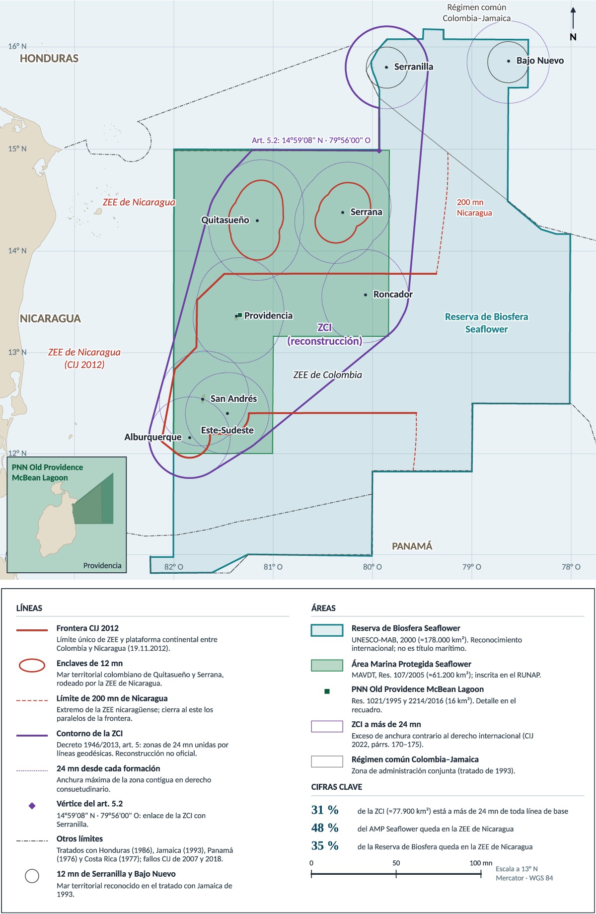
Figure 1. Prepared by the authors
Overlay of the reconstructed Integral Contiguous Zone, the archipelago’s conservation areas, and the delimitation established by the International Court of Justice in 2012. Source: prepared by the authors (2026) using National Natural Parks of Colombia (RUNAP), INVEMAR–CORALINA, Flanders Marine Institute (Maritime Boundaries Geodatabase v12, CC BY 4.0), Natural Earth, and Decree 1946 of 2013. The Integral Contiguous Zone is an unofficial reconstruction using approximate baselines; the areas stated in the text are estimates calculated using an equal-area projection.
This does not diminish the importance of cooperation to protect ecosystems whose ecological connectivity extends beyond political boundaries. Species movements, ocean currents, and environmental degradation make it necessary to combine scientific knowledge, planning instruments, and cooperation mechanisms among authorities. In a territory such as the archipelago, where communities with longstanding ties to the sea coexist with ecosystems that are especially sensitive to human pressures, legal clarity helps facilitate institutional coordination. Conservation requires reliable spatial evidence, but also certainty about which authority is competent to act, the legal basis for that competence, and the jurisdictional area in which it may be exercised.
What a Baselines Decree Can and Cannot Do
Since the content of the announced decree is not yet known, it is more useful to clarify the range of options available than to predict the line it will establish. One possible scenario is technical in nature: the decree would identify the low-water line, outer reefs, and baseline points for each formation, using straight segments only where justified by the geography. Such an instrument would fulfill, forty-eight years later, the mandate established by Law 10 of 1978 and provide certainty for measuring the territorial sea and contiguous zone. A second, broader scenario would connect the most distant formations through a continuous perimeter and treat the enclosed area as internal waters. Some press reports have suggested this possibility, although the Government has not published the text of the decree (Bloomberg Línea, 2026; Office of the President of the Republic of Colombia, 2026).
Figure 1 helps illustrate the implications of the second alternative. A perimeter connecting Alburquerque, San Andrés, Providencia, Quitasueño, Serrana, Roncador, and the East-Southeast Cays would enclose waters that the 2012 judgment attributed to Nicaragua’s exclusive economic zone, particularly north of the parallel followed by the boundary from Providencia and around the Quitasueño and Serrana enclaves. Such an outcome would encounter three limits that no decree can overcome on its own: it cannot modify a delimitation established by the Court, extend the contiguous zone beyond twenty-four nautical miles, or reinstate powers that the 2022 judgment found incompatible with international law. In addition, archipelagic baselines are reserved for archipelagic States, while straight baselines are subject to the restrictive geographic conditions that Colombia itself successfully invoked against Nicaragua in 2022. The standard applied to another State will presumably also be applied to Colombia’s proposed line (United Nations, 1982, arts. 7, 46, and 47; International Court of Justice, 2012; International Court of Justice, 2022, paras. 234–260).
Whatever its approach, the decree can be assessed by asking a few straightforward questions. Does it identify the chart, scale, datum, and tide-gauge source for each point? Does it specify whether each point corresponds to an island, a low-tide elevation, or a reef? Does it justify the method used for each segment, whether normal, reef-based, or straight? Does it respect the twelve-nautical-mile territorial sea and the twenty-four-nautical-mile contiguous zone? What effect does it have on the 2012 boundary and the rights of third States? Does it assign each maritime space only those powers permitted under its legal regime? Is it published with a coordinate annex and an identifiable chart? The answers will make it possible to distinguish an exercise in technical precision from a claim of a different scope, and to assess its consequences independently of the statements accompanying its issuance.
The Situation as of the End of October 2026
The information gathered describes a regulatory and technical sequence that remains open. Since 1978, Colombia has had a duty to determine and publish baselines; in 1984 it adopted segments for its mainland coasts; in 2013 it regulated the island territories’ maritime spaces through Decree 1946; and in 2014 it amended the procedure for their cartographic representation. DIMAR had issued eight thematic charts in 2013, and a representation of the Integral Contiguous Zone is also included in the record of the International Court of Justice. The case law of 2012, 2022, and 2023 provides the international framework for understanding the scope of maritime entitlements and the powers that may be exercised in each space (Congress of Colombia, 1978; General Maritime Directorate, 2013; International Court of Justice, 2022).
In this context, the Office of the President of the Republic reported on October 18, 2026, that a decree intended to formalize the archipelago’s baselines through official coordinates was scheduled to be issued on November 30. The announcement provides a temporal reference for understanding the current relevance of the issue, but the instrument’s final content must be assessed on the basis of its text and technical annexes once published. As of October 20, 2026, the official sources consulted for this review did not contain a final text accompanied by all the relevant coordinates. It is therefore not possible to describe a precise line in advance or establish its specific spatial consequences (Office of the President of the Republic of Colombia, 2026).
The announcement came at a time of deteriorating relations. In July 2026, the incoming government announced that Colombia would not maintain a diplomatic mission in Managua, and Nicaragua revoked the appointment of its ambassador in Bogotá. Initial reactions to the decree also reveal divergent interpretations. From within the Government, the Minister of the Interior described the 2012 ruling as “inapplicable in its literal wording,” while the President stated that Colombia would not give up a single nautical mile. Former foreign minister Julio Londoño dismissed the possibility that the measure would reopen the dispute, arguing that Nicaragua could no longer return to the Court; other specialists, such as Walter Arévalo, warned that enclosing spaces attributed to Nicaragua would contradict the 2012 judgment. At the time of this review, no official response from the Nicaraguan Government had been located (Swissinfo, 2026; Bloomberg Línea, 2026; Blu Radio, 2026).
The current state of the matter therefore cannot be reduced to anticipation of a new legal instrument. It reflects the convergence of an earlier statutory mandate, specific regulations, cartographic precedents, and international obligations that must be read together. Public access to coordinates, charts, and metadata would help make these relationships verifiable and facilitate their use in research, navigational safety, conservation, and marine spatial planning. For the archipelago, precise knowledge of the scope of each regime is a practical governance tool. The map matters, but so does the law that gives it meaning.


No Comments